| St Leonards Sydney, New South Wales | |||||||||||||||
|---|---|---|---|---|---|---|---|---|---|---|---|---|---|---|---|
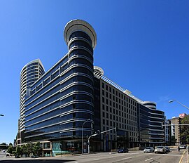
 The Forum | |||||||||||||||
 | |||||||||||||||
| Population | 7,212 (SAL 2021)[1] | ||||||||||||||
| • Density | 9,015/km2 (23,350/sq mi) | ||||||||||||||
| Established | 1853 | ||||||||||||||
| Postcode(s) | 2065 | ||||||||||||||
| Elevation | 101 m (331 ft) | ||||||||||||||
| Area | 0.8 km2 (0.3 sq mi) | ||||||||||||||
| Location | 5 km (3 mi) north of Sydney CBD | ||||||||||||||
| LGA(s) | |||||||||||||||
| State electorate(s) | |||||||||||||||
| Federal division(s) | North Sydney | ||||||||||||||
| |||||||||||||||
St Leonards is a suburb on the lower North Shore of Sydney, Australia. St Leonards is located 5 km (3.1 mi) north-west of the Sydney central business district and lies across the local government areas of Municipality of Lane Cove, North Sydney Council and the City of Willoughby.
- ^ Australian Bureau of Statistics (28 June 2022). "St Leonards (NSW) (suburb and locality)". Australian Census 2021 QuickStats. Retrieved 28 June 2022.