This article needs additional citations for verification. (January 2010) |
St Mawes
| |
|---|---|
| Village | |
 | |
Location within Cornwall | |
| OS grid reference | SW845330 |
| Civil parish | |
| Unitary authority | |
| Ceremonial county | |
| Region | |
| Country | England |
| Sovereign state | United Kingdom |
| Post town | Truro |
| Postcode district | TR2 |
| Police | Devon and Cornwall |
| Fire | Cornwall |
| Ambulance | South Western |
| UK Parliament | |
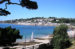
St Mawes (Cornish: Lannvowsedh) is a village on the end of the Roseland Peninsula, in the eastern side of Falmouth harbour, on the south coast of Cornwall, England. The village, formerly two separate hamlets, lies on the east bank of the Carrick Roads, a large waterway created after the Ice Age from an ancient valley which flooded as the melt waters caused the sea level to rise. The immense natural harbour thus created is claimed to be the third largest in the world. St Mawes was once a busy fishing port, but the trade declined during the 20th century and the village now serves as a popular tourist location, with many properties functioning as holiday accommodation.[citation needed] The village is in the civil parish of St Just in Roseland and lies within the Cornwall Area of Outstanding Natural Beauty (AONB).
