St Ouen
St Ouën (Jèrriais) | |
|---|---|
| Parish of St Ouen | |
 Cliffs at Plémont | |
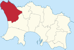
 Location of St Ouen in Jersey | |
| Crown Dependency | Jersey, Channel Islands |
| Headquarters | Parish Hall, La Rue de Vinchelez |
| Government | |
| • Connétable | Richard Buchanan (Jersey Alliance) |
| Area | |
| • Total | 15 km2 (6 sq mi) |
| • Rank | Ranked 1st |
| Population (2021)[2] | |
| • Total | 4,206 |
| • Density | 280/km2 (730/sq mi) |
| Time zone | GMT |
| • Summer (DST) | UTC+01 |
| Postcode format | |
| Website | stouen.je |
St Ouen (Jèrriais: Saint Ouën, French: Saint-Ouen) is one of the twelve parishes of Jersey in the Channel Islands. It is around 8.8 kilometres (5.5 mi) north-west of St Helier.[a] It has a population of 4,097.[3] The parish is the largest parish by surface area, covering 8,525 vergées (15 km2),[4] and is located in part on a peninsula.
The parish is largely agricultural. There is no single centre, for the church, parish hall and school are separated; St Ouen's Village is the most significant settlement in the parish. The parish hosts the northernmost section of its namesake bay, which sweeps from the north to the south of the island.
It is a distinct parish culturally. Being the farthest from St Helier, there are many differences between it and the rest of the island, for example having its own dialect of Jèrriais.
Its manor, St Ouen's Manor — the seat of the de Carteret family for over eight centuries — is the senior fief in the island, and the influence of that family has also been a factor in the parish's independent-minded approach to its affairs.[5]
- ^ "Members". Statesassembly.gov.je. Retrieved 13 October 2012.
- ^ Bulletin 1: Population characteristics. In: Census 2021. Statistics Jersey (gov.je). Census taken 21 March 2021. Published and retrieved 13 April 2022.
- ^ "2011 census results". Government of Jersey. Retrieved 21 December 2020.
- ^ States of Jersey. "Government of Jersey". gov.je. Retrieved 11 December 2020.
- ^ "Saint Ouen - theislandwiki". www.theislandwiki.org. Retrieved 11 December 2020.
Cite error: There are <ref group=lower-alpha> tags or {{efn}} templates on this page, but the references will not show without a {{reflist|group=lower-alpha}} template or {{notelist}} template (see the help page).

