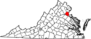
Stafford County | |
|---|---|
 Stafford County Courthouse | |
 Location within the U.S. state of Virginia | |
 Virginia's location within the U.S. | |
| Coordinates: 38°25′N 77°27′W / 38.41°N 77.45°W | |
| Country | |
| State | |
| Founded | 1664 |
| Named for | Staffordshire, England |
| Seat | Stafford |
| Largest community | Aquia Harbor |
| Area | |
• Total | 280 sq mi (700 km2) |
| • Land | 269 sq mi (700 km2) |
| • Water | 11 sq mi (30 km2) 3.9% |
| Population | |
• Total | 156,939 |
• Estimate (July 2023)[2] | 165,428 |
| • Density | 560/sq mi (220/km2) |
| Time zone | UTC−5 (Eastern) |
| • Summer (DST) | UTC−4 (EDT) |
| ZIP Codes | 22405, 22406, 22134, 22554, 22556 |
| Congressional district | 7th |
| Website | staffordcountyva |
Stafford County is a county located in the Commonwealth of Virginia. It is approximately 40 miles (64 km) south of D.C. It is part of the Northern Virginia region, and the D.C area. It is one of the fastest growing, and highest income counties in America. As of the 2020 census, the population sits at 156,927.[3] Its county seat is Stafford.[4]
Located across the Rappahannock River from the City of Fredericksburg and Spotsylvania County, Stafford County is part of the Washington-Arlington-Alexandria, DC-VA-MD-WV Metropolitan Statistical Area. In 2006, and again in 2009, Stafford was ranked by Forbes magazine as the 11th highest-income county in the United States. According to a Census Bureau report released in 2019, Stafford County is currently the sixth highest-income county in America.
- ^ Cite error: The named reference
QuickFactswas invoked but never defined (see the help page). - ^ Cite error: The named reference
Estimate2023was invoked but never defined (see the help page). - ^ "Population and Housing Unit Estimates". Retrieved November 7, 2021.
- ^ "Find a County". National Association of Counties. Retrieved June 7, 2011.