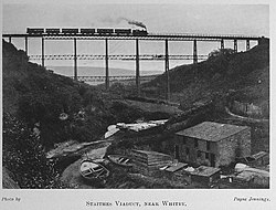
Staithes Viaduct | |
|---|---|
 Staithes viaduct | |
| Coordinates | 54°33′22″N 0°47′42″W / 54.556°N 0.795°W |
| OS grid reference | NZ77951856 |
| Crosses | Staithes Beck[note 1] |
| Locale | Staithes, North Yorkshire, England |
| Website | www |
| Preceded by | Kilton Viaduct (northwards) |
| Characteristics | |
| Material | Iron and concrete |
| Total length | 790 feet (240 m) |
| Height | 152 feet (46 m) |
| No. of spans | 17 |
| Piers in water | 1 |
| Rail characteristics | |
| No. of tracks | 1 |
| History | |
| Fabrication by | Skerne Works |
| Opened | 1875 |
| Closed | 1958 |
| Location | |
 | |
Staithes Viaduct was a railway bridge that straddled Staithes Beck at Staithes, Yorkshire, England. It was north of the closed Staithes railway station. It was known for an anemometer, a fitting to tell the signaller if winds across the viaduct were too strong for crossing trains.
Major crossing structures, including the viaduct, on the Whitby to Loftus line were made out of iron, with the piers additionally filled with concrete. The viaduct started to be built in 1875 and opened in 1883 – due to financial, build and ownership problems. The line closed in 1958 and the viaduct demolished in 1960.
Cite error: There are <ref group=note> tags on this page, but the references will not show without a {{reflist|group=note}} template (see the help page).