| Stalbridge | |
|---|---|
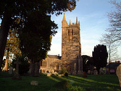
 St Mary's Church | |
 Street map | |
Location within Dorset | |
| Population | 2,668 (2021) |
| OS grid reference | ST735177 |
| Unitary authority | |
| Ceremonial county | |
| Region | |
| Country | England |
| Sovereign state | United Kingdom |
| Post town | Sturminster Newton |
| Postcode district | DT10 |
| Dialling code | 01963 |
| Police | Dorset |
| Fire | Dorset and Wiltshire |
| Ambulance | South Western |
| UK Parliament | |
| Website | Stalbridge Council |
Stalbridge (/ˈstɔːlbrɪdʒ/)[1] is a town and civil parish in Dorset, England, situated in the Blackmore Vale, near the border with Somerset. In the 2021 census the civil parish—which includes the hamlets of Stalbridge Weston, and Thornhill—had 1,224 households and a population of 2,668.[2] The nearest towns are Sturminster Newton, four miles (six kilometres) southeast, Sherborne, 6 mi (10 km) west, and Shaftesbury, 7 mi (11 km) northeast. Stalbridge is situated on the A357 on a low limestone ridge, one mile (1.5 kilometres) west of the River Stour. It officially became a town in April 1992.[3]
Though relatively small, Stalbridge has its own independent supermarket, dispensing pharmacy, dentist and optician, as well as many other services, reflecting its catchment area of surrounding farms and hamlets. It is also home to the local free newspaper, the Blackmore Vale Magazine.
- ^ Jones, Daniel (1919). An English Pronouncing Dictionary. London: Dent. p. 353.
- ^ Table PP002 - Sex, from "Parish Profiles". Office for National Statistics. Retrieved 5 August 2024.
- ^ Stalbridge Town Council, 2005. Introduction. Accessed 2005-12-30.
