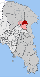
Stamata
Σταμάτα | |
|---|---|
| Coordinates: 38°07′N 23°52′E / 38.117°N 23.867°E | |
| Country | Greece |
| Administrative region | Attica |
| Regional unit | East Attica |
| Municipality | Dionysos |
| Area | |
| • Municipal unit | 18.950 km2 (7.317 sq mi) |
| Elevation | 370 m (1,210 ft) |
| Population (2021)[1] | |
| • Municipal unit | 2,901 |
| • Municipal unit density | 150/km2 (400/sq mi) |
| Time zone | UTC+2 (EET) |
| • Summer (DST) | UTC+3 (EEST) |
| Postal code | 145 75 |
| Area code(s) | 210 |
| Vehicle registration | Z |
Stamata (Greek: Σταμάτα) is a community in Athens, East Attica regional unit, Greece. Since the 2011 local government reform, it is part of the municipality Dionysos, of which it is a municipal unit.[2] The municipal unit has an area of 18.950 km2.[3]
Stamata is a rather exclusive suburb, situated in the mountainous northeastern part of the Athenian plain, between the Parnitha and Penteli mountains, about 23 km northeast of center of Athens. Till the last decades, only the main village was inhabited, while the rural area was cultivated by the inhabitants of the village. Nowadays, there are also residences in the settlement of Amygdaleza (Αμυγδαλέζα) and the residential associations of Euxeinos Pontos (Εύξεινος Πόντος) and Prokonisos (Προκόνησος). Stamata could be designated as a rural, rather than a suburban, area, but luxury houses and villas are continuously being developed, mainly in the aforementioned residential associations, turning Stamata into an upper middle class suburb.
- ^ "Αποτελέσματα Απογραφής Πληθυσμού - Κατοικιών 2021, Μόνιμος Πληθυσμός κατά οικισμό" [Results of the 2021 Population - Housing Census, Permanent population by settlement] (in Greek). Hellenic Statistical Authority. 29 March 2024.
- ^ "ΦΕΚ B 1292/2010, Kallikratis reform municipalities" (in Greek). Government Gazette.
- ^ "Population & housing census 2001 (incl. area and average elevation)" (PDF) (in Greek). National Statistical Service of Greece.

