| Stamford Hill | |
|---|---|
 | |
Location within Greater London | |
| Area | 2 sq mi (5.2 km2) |
| Population | 68,050 [1] |
| • Density | 34,025/sq mi (13,137/km2) |
| OS grid reference | TQ335875 |
| • Charing Cross | 5.5 mi (8.9 km) SSW |
| London borough | |
| Ceremonial county | Greater London |
| Region | |
| Country | England |
| Sovereign state | United Kingdom |
| Post town | LONDON |
| Postcode district | N15, N16 |
| Dialling code | 020 |
| Police | Metropolitan |
| Fire | London |
| Ambulance | London |
| UK Parliament | |
| London Assembly | |
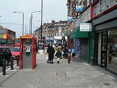
Stamford Hill is an area in Inner London, England, about 5.5 miles north-east of Charing Cross. The neighbourhood is a sub-district of Hackney, the major component of the London Borough of Hackney, and is known for its Hasidic community, the largest concentration of orthodox Ashkenazi in Europe.
The district takes its name from the eponymous hill, which reaches a height of 108 ft (33m) AOD,[2] and the originally Roman A10 also takes the name "Stamford Hill", as it makes its way through the area.
The hill is believed[3] to be named after the ford where the A10 crossed the Hackney Brook on the southern edge of the hill. Sanford and Saundfordhill are referred to in documents from the 1200s, and mean "sand Ford".[4] Roque's map of 1745 shows a bridge, which replaced the ford, referred to as "Stamford Bridge".[5]
The hill rises gently from the former course of the Hackney Brook to the south, and its steeper northern slope provided a natural boundary for the traditional (parish and borough) extent of Hackney, and now does so for the wider modern borough.
- ^ "Ward Profiles". Data.london.gov.uk. Archived from the original on 5 May 2014. Retrieved 5 May 2014.
- ^ Archaeological Study of Hackney, see page 3 https://content.historicengland.org.uk/content/docs/planning/apa-hackney.pdf
- ^ "Hackney: Newington and Stamford Hill - British History Online". British-history.ac.uk.
- ^ Oxford Dictionary of English Place Names, Ekwall, 4th Edition 1990
- ^ "Stoke Newington Common - Hackney Council". Hackney.gov.uk. Retrieved 2 September 2018.
