Stangvik Municipality
Stangvik herred | |
|---|---|
| Stangvig herred (historic name) | |
 View of the village of Stangvik (early 1900s) | |
 Møre og Romsdal within Norway | |
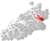
 Stangvik within Møre og Romsdal | |
| Coordinates: 62°55′10″N 08°28′05″E / 62.91944°N 8.46806°E | |
| Country | Norway |
| County | Møre og Romsdal |
| District | Nordmøre |
| Established | 1 Jan 1838 |
| • Created as | Formannskapsdistrikt |
| Disestablished | 1 Jan 1965 |
| • Succeeded by | Surnadal and Sunndal |
| Administrative centre | Stangvik |
| Area (upon dissolution) | |
| • Total | 437 km2 (169 sq mi) |
| Population (1965) | |
| • Total | 3,534 |
| • Density | 8.1/km2 (21/sq mi) |
| Demonym | Stangvikgjelding[1] |
| Time zone | UTC+01:00 (CET) |
| • Summer (DST) | UTC+02:00 (CEST) |
| ISO 3166 code | NO-1564[2] |
Stangvik is a former municipality in Møre og Romsdal county, Norway. The 437-square-kilometre (169 sq mi) municipality existed from 1838 until its dissolution in 1965. The municipality of Stangvik (historically spelled Stangvig) encompassed much of the area surrounding the Trongfjorden and the smaller fjords that branch off of it such as the Ålvundfjorden, Stangvikfjorden, and Todalsfjorden. The municipality was mostly located in what is now Surnadal Municipality and also small portions of what is now Sunndal Municipality and Tingvoll Municipality. The administrative centre of the municipality was the village of Stangvik where Stangvik Church is located.[3]
- ^ "Navn på steder og personer: Innbyggjarnamn" (in Norwegian). Språkrådet.
- ^ Bolstad, Erik; Thorsnæs, Geir, eds. (26 January 2023). "Kommunenummer". Store norske leksikon (in Norwegian). Kunnskapsforlaget.
- ^ Thorsnæs, Geir, ed. (22 February 2017). "Stangvik - tidligere kommune". Store norske leksikon (in Norwegian). Kunnskapsforlaget. Retrieved 15 April 2019.