| Stanmore | |
|---|---|
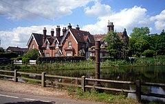
 Pump at one of the Roman-era ponds at Little Common, which gave Stanmore its name | |
Location within Greater London | |
| Population | 23,700 (Stanmore Park and Canons wards 2011) |
| OS grid reference | TQ1691 |
| London borough | |
| Ceremonial county | Greater London |
| Region | |
| Country | England |
| Sovereign state | United Kingdom |
| Post town | STANMORE |
| Postcode district | HA7 |
| Dialling code | 020 |
| Police | Metropolitan |
| Fire | London |
| Ambulance | London |
| UK Parliament | |
| London Assembly | |
Stanmore is part of the London Borough of Harrow in Greater London. It is centred 11 miles (18 km) northwest of Charing Cross, lies on the outskirts of the London urban area and includes Stanmore Hill, one of the highest points of London, at 152 metres (499 ft) high. The district, which developed from the ancient Middlesex parishes of Great and Little Stanmore, lies immediately west of Roman Watling Street (the A5 road) and forms the eastern part of the modern London Borough of Harrow.
Stanmore is the location of the former RAF Bentley Priory station – base of the Fighter Command during both world wars – along with its accommodating Bentley Priory mansion, notably the last residence of Queen Adelaide. Some members of the Bernays family were also based here, including Adolphus Bernays and his son and grandson who were both rectors of St John's church; the Bernays Institute and Bernays Gardens are public amenities in the centre of the old village.[1]
The district increasingly developed into a London suburb during the 20th century, and in the latter half housed the Automobile Association's regional headquarters. Today it is a commuter town[2] with a tube station that is the northern terminus of the Jubilee line,[3] and large green spaces.
