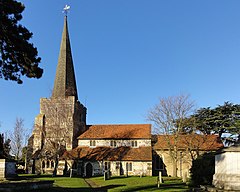
| Stanwell | |
|---|---|
 | |
Location within Surrey | |
| Area | 5.13 km2 (1.98 sq mi) |
| Population | 11,279 (2011 census)[1] |
| • Density | 2,199/km2 (5,700/sq mi) |
| OS grid reference | TQ055735 |
| District | |
| Shire county | |
| Region | |
| Country | England |
| Sovereign state | United Kingdom |
| Post town | Staines-upon-Thames |
| Postcode district | TW19 |
| Dialling code | 01784 |
| Police | Surrey |
| Fire | Surrey |
| Ambulance | South East Coast |
| UK Parliament | |
Stanwell is a village in the Spelthorne district, in Surrey, England. It is 16 miles (26 km) west of central London. A small corner of its land is used as industrial land for nearby Heathrow Airport. The rest of the village is made up of residential and recreational land. Historically part of the county of Middlesex, it has, like the rest of Spelthorne, been in Surrey since 1965. The village is to the south of the cargo-handling area of Heathrow Airport and to the east of the Staines Reservoirs. Stanwell is the northernmost settlement in Surrey, bordering Berkshire and Greater London.
Its recognisable extent has been substantially cut three times – all in the 20th century. Land was taken for reservoirs in about 1900; a few decades later land was taken into Heathrow Airport; and in 1995, after the completion of the M25 motorway, the settlement of Poyle (beyond Stanwell Moor) was detached from the Borough and reassigned to Colnbrook in the Borough of Slough.
Stanwell Moor is near the village and has multiple reservoirs around it. It was recognised as a manor in medieval times. It has a few pasture/horse-riding fields, horticultural businesses and flood meadows. It is centred 1 mile (1.6 km) from the historical nucleus of Stanwell and is part of the same ward and ecclesiastical parish.
- ^ Key Statistics; Quick Statistics: Population Density United Kingdom Census 2011 Office for National Statistics Stanwell makes up 2011 lower output areas Spelthorne 001 and 001 with suffixes A, B and C. Note: the towns and villages in Spelthorne have one ward each which covers part of a neighbouring town or village. For example, Ashford is two wards and part of a third ward (see Government). Retrieved 21 November 2013
