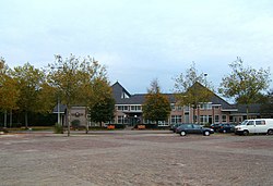
Staphorst | |
|---|---|
 Staphorst city hall | |
 Location in Overijssel | |
| Coordinates: 52°39′N 6°13′E / 52.650°N 6.217°E | |
| Country | Netherlands |
| Province | Overijssel |
| Government | |
| • Body | Municipal council |
| • Mayor | [Lenard Horstede] (CU) |
| Area | |
| • Total | 135.69 km2 (52.39 sq mi) |
| • Land | 133.99 km2 (51.73 sq mi) |
| • Water | 1.70 km2 (0.66 sq mi) |
| Elevation | 1 m (3 ft) |
| Population (January 2021)[4] | |
| • Total | 17,261 |
| • Density | 129/km2 (330/sq mi) |
| Demonym(s) | Staphorstenaar, Staphorster |
| Time zone | UTC+1 (CET) |
| • Summer (DST) | UTC+2 (CEST) |
| Postcode | 7715, 7950–7955 |
| Area code | 0522 |
| Website | www |

Staphorst (Dutch pronunciation: [ˈstɑpɦɔrst] ) is a municipality and a town in the eastern Netherlands.
- ^ "College van B&W" [Board of mayor and aldermen] (in Dutch). Gemeente Staphorst. Archived from the original on 16 April 2014. Retrieved 1 April 2014.
- ^ "Kerncijfers wijken en buurten 2020" [Key figures for neighbourhoods 2020]. StatLine (in Dutch). CBS. 24 July 2020. Retrieved 19 September 2020.
- ^ "Postcodetool for 7951DE". Actueel Hoogtebestand Nederland (in Dutch). Het Waterschapshuis. Retrieved 1 April 2014.
- ^ "Bevolkingsontwikkeling; regio per maand" [Population growth; regions per month]. CBS Statline (in Dutch). CBS. 1 January 2021. Retrieved 2 January 2022.


