| Stapleford | |
|---|---|
| Town and civil parish | |
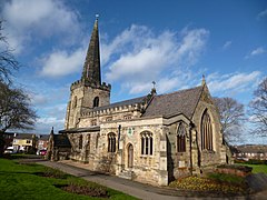
 St Helens Church, Stapleford | |
 Parish map | |
Location within Nottinghamshire | |
| Area | 1.65 sq mi (4.3 km2) |
| Population | 15,453 (2021) |
| • Density | 9,365/sq mi (3,616/km2) |
| OS grid reference | SK 48796 37125 |
| • London | 110 mi (180 km) SSE |
| District | |
| Shire county | |
| Region | |
| Country | England |
| Sovereign state | United Kingdom |
| Post town | NOTTINGHAM |
| Postcode district | NG9 |
| Dialling code | 0115 |
| Police | Nottinghamshire |
| Fire | Nottinghamshire |
| Ambulance | East Midlands |
| UK Parliament | |
| Website | stapleford-tc |
Stapleford (/ˈsteɪpəlfərd/) is a town and civil parish in the Borough of Broxtowe, Nottinghamshire, England, 6 miles (9.7 km) west of Nottingham. The population of the civil parish at the 2001 census was 14,991,[1] at the 2011 census it was 15,241,[2] and 15,453 at the 2021 census.[3]
- ^ UK Census (2001). "Local Area Report – Stapleford (37UD008)". Nomis. Office for National Statistics. Retrieved 26 January 2024.
- ^ "Town population 2011". Neighbourhood Statistics. Office for National Statistics. Retrieved 14 April 2016.
- ^ UK Census (2021). "2021 Census Area Profile – Stapleford (Broxtowe) parish (E04007862)". Nomis. Office for National Statistics. Retrieved 26 January 2024.
