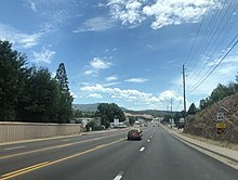
Star Valley, Arizona | |
|---|---|
 Location of Star Valley in Gila County, Arizona | |
| Coordinates: 33°21′4″N 110°27′36″W / 33.35111°N 110.46000°W | |
| Country | United States |
| State | Arizona |
| Counties | Gila |
| Incorporated | 2005 |
| Government | |
| • Type | Council-manager |
| • Mayor | Bobby Davis |
| • Town Manager | Timothy Grier |
| Area | |
| • Total | 36.15 sq mi (93.64 km2) |
| • Land | 36.14 sq mi (93.61 km2) |
| • Water | 0.01 sq mi (0.02 km2) |
| Elevation | 4,650 ft (1,420 m) |
| Population (2020) | |
| • Total | 2,484 |
| • Density | 68.73/sq mi (26.54/km2) |
| Time zone | UTC-7 (MST (no DST)) |
| ZIP code | 85541[2] |
| Area code | 928 |
| FIPS code | 04-69480 |
| Website | starvalleyaz |

Star Valley is a town in Gila County, Arizona, United States, incorporated in 2005. Before incorporation, it was a census-designated place (CDP). As of the 2020 census the population of the town was 2,484.[3]
- ^ "2020 U.S. Gazetteer Files". United States Census Bureau. Retrieved October 29, 2021.
- ^ "Star Valley AZ ZIP Code". zipdatamaps.com. 2023. Retrieved January 26, 2023.
- ^ "Explore Census Data". data.census.gov. Retrieved June 13, 2024.

