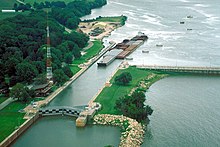
| Starved Rock Lock and Dam | |
|---|---|
 Barges passing through Starved Rock Lock and Dam | |
| Official name | Lock and Dam No. 6 |
| Location | LaSalle County/Utica, Illinois (Starved Rock State Park), United States |
| Coordinates | 41°19′21″N 88°59′8″W / 41.32250°N 88.98556°W |
| Status | Operational |
| Construction began | 1926 |
| Opening date | 1933 |
| Operator(s) | United States Army Corps of Engineers |
| Dam and spillways | |
| Type of dam | Gravity dam |
| Impounds | Illinois River |
| Height | 34 ft (10 m) |
| Length | 1,310 ft (400 m) |
| Width (base) | 33 ft (10 m) |
| Spillway type | Controlled |
Starved Rock Lock and Dam, also known as Lock and Dam No. 6, is a lock and dam facility managed by the U.S. Army Corps of Engineers along the Illinois River, near Starved Rock. It is part of the Illinois Waterway and was constructed between 1926 and 1933. The lock and dam was added to the National Register of Historic Places as the Starved Rock Lock and Dam Historic District in 2004.