This article needs additional citations for verification. (June 2008) |
| State Highway 30 | ||||
|---|---|---|---|---|
 | ||||
| Route information | ||||
| Maintained by NZ Transport Agency | ||||
| Length | 219 km (136 mi) | |||
| Tourist routes | Thermal Explorer Highway in concurrency with SH 5 Pacific Coast Highway Paroa to Whakatane | |||
| Major junctions | ||||
| Southwest end | ||||
| Northeast end | Landing Road in Whakatane | |||
| Location | ||||
| Country | New Zealand | |||
| Primary destinations | Mangakino, Ātiamuri, Rotorua, Awakeri | |||
| Highway system | ||||
| ||||
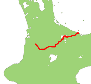
State Highway 30 (SH 30) is a New Zealand state highway, linking the Waikato and Bay of Plenty towns of Te Kūiti, Mangakino, Rotorua, and Whakatāne.
At 219 kilometres, SH 30 is New Zealand's fifth longest provincial (two-digit) state highway, after SH 25, SH 35, SH 73, and SH 94.[1] With the exception of SH 4, it has junctions with every national (one-digit) state highway in the North Island.
SH 30 has the most concurrencies of all the state highways. It shares sections with, from west to east, SH 32, SH 1, SH 5, SH 34 (albeit briefly), and SH 2.
- ^ "State Highways: Numbers Used, Location Descriptors, and Lengths (As at January 2004)" (PDF). Retrieved 21 May 2008.
