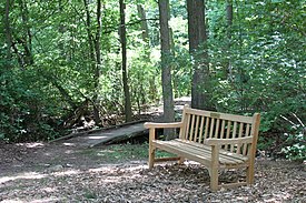
| Staten Island Greenbelt | |
|---|---|
 At Manor Road | |
 | |
| Type | Urban park |
| Location | Staten Island, New York City, United States |
| Coordinates | 40°35′18″N 74°08′21″W / 40.58846°N 74.139073°W |
| Area | 2,800 acres (11 km2) |
| Created | 1984 |
| Owned by | NYC Parks |
| Operated by | Greenbelt Conservancy |
| Status | Open all year |
| Website | www |
The Staten Island Greenbelt is a system of contiguous public parkland and natural areas in the central hills of the New York City borough of Staten Island. It is the second largest component of the parks owned by the government of New York City and is maintained by the city's Department of Parks and Recreation and the Greenbelt Conservancy, a not-for-profit organization that works in partnership with NYC Parks to care for the Greenbelt and raise funds for its maintenance and programs. The Greenbelt includes High Rock Park, LaTourette Park, William T. Davis Wildlife Refuge, and Willowbrook Park among others.[1]
- ^ "The Greenbelt". nycgovparks. Retrieved 28 May 2020.