Stathelle | |
|---|---|
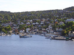
 View of the town | |
| Coordinates: 59°02′42″N 9°41′54″E / 59.04511°N 9.69821°E | |
| Country | Norway |
| Region | Eastern Norway |
| County | Telemark |
| District | Grenland |
| Municipality | Bamble Municipality |
| Established as | |
| Ladested | 1774 |
| Elevation | 4 m (13 ft) |
| Time zone | UTC+01:00 (CET) |
| • Summer (DST) | UTC+02:00 (CEST) |
| Post Code | 3960 Stathelle |
| Stathelle ladested | |
 Telemark within Norway | |
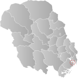
 Stathelle within Telemark | |
| Country | Norway |
| County | Telemark |
| District | Grenland |
| Established | 1 Jan 1838 |
| • Created as | Formannskapsdistrikt |
| Disestablished | 1 Jan 1964 |
| • Succeeded by | Bamble Municipality |
| Administrative centre | Stathelle |
| Population (1964) | |
| • Total | 724 |
| ISO 3166 code | NO-0803[3] |
is a town in Bamble Municipality in Telemark county, Norway. The town is located at the confluence of the Frierfjorden, Eidangerfjord, and Langesundsfjorden. The town of Brevik lies about 1 kilometre (0.62 mi) across the fjord and the town of Langesund lies about 4 kilometres (2.5 mi) to the southeast. Stathelle Church is located in the town.[4]
For a long time, Stathelle and neighboring Langesund have been grouped together as part of the Porsgrunn/Skien metropolitan area and because of this, the population and area data for this town has not been separately tracked by Statistics Norway. What is tracked, is the portion of the metropolitan area located in Bamble Municipality. In 2022, the Langesund/Stathelle area in Bamble measured 6.34 square kilometres (1,570 acres) and together they had a population of 10,276 with a population density of 1,622 inhabitants per square kilometre (4,200/sq mi).[5]
- ^ In the Norwegian language, the word by can be translated as "town" or "city".
- ^ "Stathelle, Bamble". yr.no. Retrieved 19 September 2023.
- ^ Bolstad, Erik; Thorsnæs, Geir, eds. (26 January 2023). "Kommunenummer". Store norske leksikon (in Norwegian). Kunnskapsforlaget.
- ^ Lundbo, Sten, ed. (30 June 2022). "Stathelle". Store norske leksikon (in Norwegian). Kunnskapsforlaget. Retrieved 20 September 2023.
- ^ Statistisk sentralbyrå (1 January 2022). "Urban settlements. Population and area, by municipality".

