| Staunton Harold | |
|---|---|
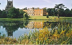
 Staunton Harold Hall, with the tower of Holy Trinity Chapel on the left and the lake in the foreground | |
Location within Leicestershire | |
| Population | 141 (2011 Census) |
| OS grid reference | SK3720 |
| Civil parish |
|
| District | |
| Shire county | |
| Region | |
| Country | England |
| Sovereign state | United Kingdom |
| Post town | Ashby-de-la-Zouch |
| Postcode district | LE65 |
| Dialling code | 01332 |
| Police | Leicestershire |
| Fire | Leicestershire |
| Ambulance | East Midlands |
| UK Parliament | |
| Website | Staunton Harold Parish Meeting |
Staunton Harold is a civil parish in North West Leicestershire about 3 miles (5 km) north of Ashby-de-la-Zouch. The parish is on the county boundary with Derbyshire and about 9 miles (14 km) south of Derby. The 2011 Census (including Lount) recorded the parish's population as 141.[1]
A brook flows from the south through the parish, heading for the River Trent which it joins about 4 miles (6.4 km) to the north. In the parish the brook is dammed to form a pair of small lakes. Nikolaus Pevsner (later Sir Nikolaus) described the view westwards across the lakes to Staunton Harold Hall and Holy Trinity parish church as "unsurpassed in the country – certainly as far as Englishness is concerned".[2]
Downstream from Staunton Harold, just over 1 mile (1.6 km) over the boundary in Derbyshire, the brook is dammed again to form Staunton Harold Reservoir. Most of the reservoir is in the Derbyshire parish of Melbourne, but part of the upper reach of one arm of the reservoir is in Staunton Harold parish.
- ^ "Area: Staunton Harold (Parish): Key Figures for 2011 Census: Key Statistics". Neighbourhood Statistics. Office for National Statistics. Retrieved 22 March 2015.
- ^ Pevsner 1960, p. 238.
