| Stave Falls Dam | |
|---|---|
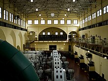
 Interior of the original Stave Falls power house | |
| Country | Canada |
| Location | Stave Falls |
| Coordinates | 49°13′47″N 122°21′20″W / 49.22972°N 122.35556°W |
| Status | Operational |
| Construction began | 1909 |
| Opening date | 1912 |
| Owner(s) | BC Hydro |
| Dam and spillways | |
| Impounds | Stave River |
| Length | 122 m (400 ft) Blind Slough Dam: 190 m (623 ft) |
| Elevation at crest | 83.75 m (275 ft) |
| Width (crest) | 5 m (16 ft) Blind Slough Dam: 8.5 m (28 ft) |
| Spillways | 2 |
| Spillway type | Sluice/Tainter gate controlled |
| Spillway capacity | 3,500 m3/s (123,601 cu ft/s) |
| Reservoir | |
| Creates | Stave Lake |
| Total capacity | 470,000,000 m3 (381,035 acre⋅ft) |
| Catchment area | 1,170 km2 (452 sq mi) |
| Surface area | 62 km2 (24 sq mi) |
| Normal elevation | 82 m (269 ft) |
| Power Station | |
| Operator(s) | BC Hydro |
| Commission date | Original: 1911 New: 2000 |
| Turbines | 2 x 45 MW Kaplan turbines |
| Installed capacity | 90 MW |
| Annual generation | 362 GWh |
| Official name | Stave Falls Hydro-Electric Installation National Historic Site of Canada |
| Designated | 2003 |
Stave Falls Dam is a dual-dam power complex on the Stave River in Stave Falls, British Columbia, Canada. The dam was completed in 1912 for the primary purpose of hydroelectric power production. To increase the capacity of Stave Lake, the dam was raised in 1925 and the Blind Slough Dam constructed in an adjacent watercourse 500 m (1,600 ft) to the north, which was the site of the eponymous Stave Falls. In 2000, the dam's powerhouse was replaced after a four-year upgrade. The original Stave Falls powerhouse was once British Columbia's largest hydroelectric power source, and is a National Historic Site of Canada.[1][2]
- ^ "Mission Historic & Heritage Sites". Hello BC. Retrieved 26 June 2011.
- ^ Stave Falls Hydro-Electric Installation. Canadian Register of Historic Places. Retrieved 1 February 2012.
