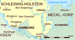
| Stecknitz Canal | |
|---|---|
 The modern Elbe–Lübeck Canal in eastern Schleswig-Holstein | |
 | |
| Specifications | |
| Length | 60 miles (97 km) (Man-made segment ran for 11.5 kilometres (7.1 mi)) |
| Locks | 17 (originally 13) |
| Maximum height above sea level | 56 ft (17 m) |
| Status | replaced by Elbe–Lübeck Canal |
| History | |
| Date of act | 1390 |
| Construction began | 1391 |
| Date completed | 1398 |
| Date closed | 1893 |
| Geography | |
| Start point | Lauenburg (Elbe) |
| End point | Lübeck (Trave) |
The Stecknitz Canal (German: Stecknitzfahrt) was an artificial waterway in northern Germany which connected Lauenburg and Lübeck on the Old Salt Route by linking the tiny rivers Stecknitz (a tributary of the Trave) and Delvenau (a tributary of the Elbe), thus establishing an inland water route across the drainage divide from the North Sea to the Baltic Sea. Built between 1391 and 1398, the Stecknitz Canal was the first European summit-level canal and one of the earliest artificial waterways in Europe.[1] In the 1890s the canal was replaced by an enlarged and straightened waterway called the Elbe–Lübeck Canal, which includes some of the Stecknitz Canal's watercourse.[2]
The original artificial canal was 0.85 metres (33 in) deep and 7.5 metres (25 ft) wide; the man-made segment ran for 11.5 kilometres (7.1 mi), with a total length of 97 kilometres (60 mi) including the rivers it linked. The canal included seventeen wooden locks (of which the Palmschleuse at Lauenburg still exists) that managed the 13-metre (43 ft) elevation difference between its endpoints and the highest central part, the Delvenaugraben.[3]
- ^ Zumerchik, John; Danver, Steven Laurence (2010). Seas and Waterways of the World: An Encyclopedia of History, Uses, and Issues. Vol. 1. ABC-CLIO. pp. 118, 121. ISBN 9781851097111. Retrieved 27 May 2016.
- ^ Clarke, Michael. "Stecknitz Canal". Encyclopædia Britannica. Retrieved 27 May 2016.
- ^ "Stecknitzkanal". Brockhaus' Konversations-Lexikon (in German). Vol. 15 (14th ed.). Leipzig: F.A. Brockhaus AG. 1908. p. 273. Retrieved 27 May 2016.