Steenbergen | |
|---|---|
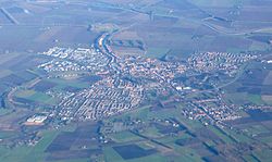
 Aerial view of Steenbergen | |
 Location in North Brabant | |
| Coordinates: 51°35′N 4°19′E / 51.583°N 4.317°E | |
| Country | Netherlands |
| Province | North Brabant |
| Government | |
| • Body | Municipal council |
| • Mayor | Ruud van den Belt (VVD) |
| Area | |
| • Total | 159.14 km2 (61.44 sq mi) |
| • Land | 146.43 km2 (56.54 sq mi) |
| • Water | 12.71 km2 (4.91 sq mi) |
| Elevation | 1 m (3 ft) |
| Population (January 2021)[4] | |
| • Total | 24,310 |
| • Density | 166/km2 (430/sq mi) |
| Demonym | Steenbergenaar |
| Time zone | UTC+1 (CET) |
| • Summer (DST) | UTC+2 (CEST) |
| Postcode | 4650–4655, 4670–4671, 4680–4681, 4756 |
| Area code | 0167 |
| Website | gemeente-steenbergen |
Steenbergen (Dutch pronunciation: [ˈsteːmbɛrɣə(n)] ) is a municipality and a town in the province of North Brabant in the south of the Netherlands. The municipality had a population of 24,310 in 2021 and covers an area of 159.14 km2 (61.44 sq mi) of which 12.71 km2 (4.91 sq mi) is water. The municipality is mainly agricultural including a strongly growing greenhouse sector, but Steenbergen and the nearby town of Dinteloord also contain some light industry. A new stretch of A4 motorway under construction is expected to further increase the municipality's attractiveness, allowing easy connections with the large cities of Rotterdam to the north and the Belgian city of Antwerp to the south. The connection with the nearby city of Bergen op Zoom will also be improved as a result.
- ^ "Belt van den, Ruud" (in Dutch). Gemeente Steenbergen. Retrieved 5 June 2014.
- ^ "Kerncijfers wijken en buurten 2020" [Key figures for neighbourhoods 2020]. StatLine (in Dutch). CBS. 24 July 2020. Retrieved 19 September 2020.
- ^ "Postcodetool for 4652GA". Actueel Hoogtebestand Nederland (in Dutch). Het Waterschapshuis. Retrieved 5 June 2014.
- ^ "Bevolkingsontwikkeling; regio per maand" [Population growth; regions per month]. CBS Statline (in Dutch). CBS. 1 January 2021. Retrieved 2 January 2022.

