Steinsel
Steesel | |
|---|---|
 | |
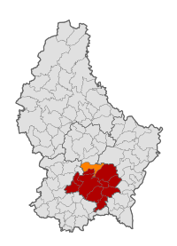
 Map of Luxembourg with Steinsel highlighted in orange, and the canton in dark red | |
| Coordinates: 49°40′35″N 6°07′25″E / 49.6764°N 6.1236°E | |
| Country | |
| Canton | Luxembourg |
| Government | |
| • Mayor | Fernand Marchetti |
| Area | |
• Total | 21.81 km2 (8.42 sq mi) |
| • Rank | 47th of 100 |
| Highest elevation | 373 m (1,224 ft) |
| • Rank | 71st of 100 |
| Lowest elevation | 241 m (791 ft) |
| • Rank | 47th of 100 |
| Population (2023) | |
• Total | 5,539 |
| • Rank | 27th of 100 |
| • Density | 250/km2 (660/sq mi) |
| • Rank | 31st of 100 |
| Time zone | UTC+1 (CET) |
| • Summer (DST) | UTC+2 (CEST) |
| LAU 2 | LU0000308 |
| Website | steinsel.lu |
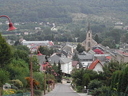
Steinsel (Luxembourgish: Steesel [ˈʃteːzəl] ) is a commune and town in central Luxembourg. It is located north of Luxembourg City.
As of 2023[update], the town of Steinsel, which lies in the west of the commune, has a population of 2,549. Other towns within the commune include Heisdorf and Mullendorf.[1]
Like most of Luxembourg, Steinsel has an oceanic climate. On 25 July 2019, Steinsel recorded a temperature of 40.8 °C (105.4 °F), which is the highest temperature to have ever been recorded in Luxembourg.[2]

- ^ "Registre national des personnes physiques RNPP : Population par localité". data.public.lu. 2024-01-07.
- ^ "40,8 °C: Neuer offizieller Temperaturrekord in Luxemburg" [40.8 °C: New official temperature record in Luxembourg] (in German). AgriMeteo. Archived from the original on 26 July 2019. Retrieved 25 July 2019.
