Stevens Square-Loring Heights | |
|---|---|
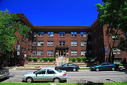
 Stevens Court, the oldest contributing building in the Stevens Square Historic District, built in 1913. | |
 Location of Stevens Square/Loring Heights within the U.S. city of Minneapolis | |
| Coordinates: 44°57′53″N 93°16′29″W / 44.96472°N 93.27472°W | |
| Country | United States |
| State | Minnesota |
| County | Hennepin |
| City | Minneapolis |
| Community | Central |
| City Council Wards | 6, 7 |
| Government | |
| • Council Member | Jamal Osman |
| • Council Member | Katie Cashman |
| Area | |
| • Total | 0.187 sq mi (0.48 km2) |
| Elevation | 863 ft (263 m) |
| Population (2020)[2] | |
| • Total | 4,137 |
| • Density | 22,000/sq mi (8,500/km2) |
| Time zone | UTC-6 (CST) |
| • Summer (DST) | UTC-5 (CDT) |
| ZIP code | 55403, 55404, 55405 |
| Area code | 612 |
Stevens Square Historic District | |
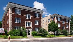
 Two 1915 apartment buildings typical of Stevens Square | |
| Location | Minneapolis, Minnesota |
|---|---|
| Built | 1912 |
| Architect | Multiple |
| Architectural style | Late 19th and 20th Century Revivals, Renaissance, Gothic Revival |
| NRHP reference No. | 93000594 [3] |
| Added to NRHP | July 1, 1993 |
| Census | Pop. | Note | %± |
|---|---|---|---|
| 1980 | 3,827 | — | |
| 1990 | 4,433 | 15.8% | |
| 2000 | 3,948 | −10.9% | |
| 2010 | 3,833 | −2.9% | |
| 2020 | 4,137 | 7.9% |
Stevens Square (officially Stevens Square-Loring Heights) is the southernmost neighborhood of the Central community in Minneapolis. It is bordered on Lyndale Avenue on the west, Franklin Avenue on the south, and Interstates 94 and 35W on the north and east, respectively. The portion west of Nicollet Avenue can be referred to as Loring Heights; the portion to the East as Stevens Square.[4]
Although it is one of the densest neighborhoods in Minneapolis today, Stevens Square-Loring Heights was originally occupied by a few large mansions. Today, the area is composed mostly of old brownstone apartment buildings or mansions that have been subdivided into apartments, giving the neighborhood a heavy population density within its small geographical area; a short and wide neighborhood, it is nearly a mile long but only three blocks tall. Much of the neighborhood is a National Historic District, and five of the apartment buildings were listed on the National Register of Historic Places in 1993.[5]
Although Stevens Square faced many of the same challenges which confronted other inner-city neighborhoods through the 1990s, the neighborhood has seen significant increases in safety and average income in recent years. These have been attributed both to a successful Neighborhood Revitalization Program and to limited gentrification, with many apartments buildings converted to condominiums or co-ops.
- ^ "Stevens Square neighborhood in Minneapolis, Minnesota (MN), 55403, 55404 detailed profile". City-Data. 2011. Retrieved November 12, 2013.
- ^ "Stevens Square-Loring Heights neighborhood data". Minnesota Compass. Retrieved February 19, 2023.
- ^ "National Register Information System". National Register of Historic Places. National Park Service. March 15, 2006.
- ^ Howard, Liddy J. (May 1997). "Stevens Square-Loring Heights: "A Community Defined"". Abbot's Surgical Hospital. Action Squad. Retrieved April 22, 2024.
- ^ "Stevens Square NRP Phase II Neighborhood Action Plan" (PDF). March 5, 2005. Retrieved April 6, 2007.

