Stevensville, Montana | |
|---|---|
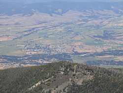
 Stevensville and the Bitterroot River seen from Saint Mary's Peak (2005) | |
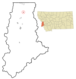
 Location of Stevensville, Montana | |
| Coordinates: 46°30′28″N 114°5′36″W / 46.50778°N 114.09333°W | |
| Country | United States |
| State | Montana |
| County | Ravalli |
| Government | |
| • Type | Mayor-Council |
| • Mayor | Steve Gibson |
| • Body | Stevensville Town Council |
| Area | |
• Total | 1.31 sq mi (3.40 km2) |
| • Land | 1.29 sq mi (3.35 km2) |
| • Water | 0.02 sq mi (0.05 km2) |
| Elevation | 3,323 ft (1,013 m) |
| Population (2020) | |
• Total | 2,002 |
| • Density | 1,545.95/sq mi (596.90/km2) |
| Time zone | UTC-7 (Mountain (MST)) |
| • Summer (DST) | UTC-6 (MDT) |
| ZIP code | 59870 |
| Area code | 406 |
| FIPS code | 30-71200 |
| GNIS feature ID | 2413335[2] |
| Website | www |
Stevensville (Salish: ɫq̓éɫmlš[3]) is a town in Ravalli County, Montana, United States. The population was 2,002 at the 2020 census.[4]
Stevensville is officially recognized as the first permanent settlement of non-indigenous peoples in the state of Montana. Forty-eight years before Montana became the nation's 41st state, Stevensville was settled by Jesuit Missionaries at the request of the Bitterroot Salish tribe.
- ^ "ArcGIS REST Services Directory". United States Census Bureau. Retrieved September 5, 2022.
- ^ a b U.S. Geological Survey Geographic Names Information System: Stevensville, Montana
- ^ Tachini, Pete; Louie Adams, Sophie Mays, Mary Lucy Parker, Johnny Arlee, Frances Vanderburg, Lucy Vanderburg, Diana Christopher-Cote (1998). nyoʻnuntn q̓éymin, Flathead Nation Salish dictionary. Pablo, Montana: Bilingual Education Department, Salish Kootenai College. p. 137.
{{cite book}}: CS1 maint: multiple names: authors list (link) - ^ "U.S. Census website". United States Census Bureau. Retrieved November 2, 2021.