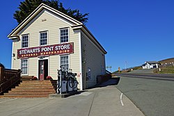
Stewarts, California | |
|---|---|
 General Store | |
| Coordinates: 38°39′07″N 123°23′57″W / 38.65194°N 123.39917°W | |
| Country | United States |
| State | California |
| County | Sonoma |
| Elevation | 108 ft (33 m) |
| Time zone | UTC-8 (Pacific (PST)) |
| • Summer (DST) | UTC-7 (PDT) |
| ZIP code | 95480 |
| Area code | 707 |
| GNIS feature ID | 252807[1] |
Stewarts Point is an unincorporated community in Sonoma County, California, United States and part of the "historic" Salt Point Township. Stewarts Point is located on the Pacific coast and California State Route 1, 20 miles (32 km) west of Healdsburg. Stewarts Point was originally part of the German Rancho, and was purchased by William Bihler in 1852. The unincorporated area is named for the first residents, the Stewart family, who moved to the area in 1856.[2] In the official history for the United States Post Office, the name was said to have been given by Lt. Col. S. Stewart in 1888, however newspaper archives refer to the area as Stewarts Point as early as 1867, and attribute the name to the Stewart family who were the first residents in the area.
Stewarts Point and the adjacent Fisherman Bay have a long and important history to the indigenous Pomo people, Kashia Band of Pomo Indians of the Stewarts Point Rancheria who have lived in the area for millennia. The large sheltered cove fed by a small creek offered access to the area's bountiful marine and coastal resources. The topographic advantages of this location were equally recognized by Euro-American settlers who set out from San Francisco to take advantage of the coastal redwood forest. John and Andrew Fisk built the first landing at Stewarts Point in 1867. By 1877, three lumber chutes shipped out products from nearby mills.[3]
The community was, and still is, an important part of California's timber industry, shipping ports, railroads, lumber mills, and tie camps operated out of the settlement.
- ^ U.S. Geological Survey Geographic Names Information System: Stewarts Point, California
- ^ Durham, David L. (1998). California's Geographic Names: A Gazetteer of Historic and Modern Names of the State. Quill Driver Books. p. 707. ISBN 1-884995-14-4.
- ^ "Doghole Port: Stewarts Point". National Oceanic and Atmospheric Administration. Retrieved December 15, 2020.

