Borough of Stockertown | |
|---|---|
 Stockertown's post office and municipal building in December 2008 | |
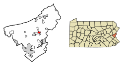
 Location of Stockertown in Northampton County, Pennsylvania (left) and of Northampton County in Pennsylvania (right) | |
Location of Stockertown in Pennsylvania | |
| Coordinates: 40°45′15″N 75°15′53″W / 40.75417°N 75.26472°W | |
| Country | |
| State | |
| County | Northampton |
| Incorporated | 1901 |
| Named for | Stocker family |
| Government | |
| • Mayor | Charles Davis |
| Area | |
| • City | 1.00 sq mi (2.59 km2) |
| • Land | 0.97 sq mi (2.51 km2) |
| • Water | 0.03 sq mi (0.08 km2) |
| Elevation | 374 ft (114 m) |
| Population (2010) | |
| • City | 927 |
| • Estimate (2019)[2] | 926 |
| • Density | 954.64/sq mi (368.76/km2) |
| • Metro | 865,310 (US: 68th) |
| Time zone | UTC-5 (EST) |
| • Summer (DST) | UTC-4 (EDT) |
| ZIP Code | 18083 |
| Area code(s) | 610 and 484 |
| FIPS code | 42-74232 |
| Primary airport | Lehigh Valley International Airport |
| Major hospital | Lehigh Valley Hospital–Cedar Crest |
| School district | Nazareth Area |
| Website | www.stockertown.org |
Stockertown is a borough in Northampton County, Pennsylvania. The borough's population was 927 as of the 2010 census. It is part of the Lehigh Valley metropolitan area, which had a population of 861,899 and was the 68th-most populous metropolitan area in the U.S. as of the 2010 census.
The borough contains large industries such as Hercules Cement, Polymer Products, and Praxair. The borough spans a 21⁄2-mile radius and provides services for a population of 927 residents. Stockertown is at the hub of five surrounding second-class townships, and until the Charles Chrin Interchange was built near Tatamy in 2015, provided the closest access to Pennsylvania Route 33 for many industrial parks in these townships.[3]
Since 2006, Forks Township has been contracted to provide fire services to the borough,[4] and the borough maintains its own police department. It is located in Pennsylvania's 17th Congressional District, and in Pennsylvania's 137th (State House of Representatives) and 18th (State Senate) Legislative Districts.[5]
- ^ "2019 U.S. Gazetteer Files". United States Census Bureau. Retrieved July 28, 2020.
- ^ Cite error: The named reference
USCensusEst2019CenPopScriptOnlyDirtyFixDoNotUsewas invoked but never defined (see the help page). - ^ "New Route 33 interchange will drive change in Northampton County". Retrieved August 20, 2015.
- ^ "About the Forks Township Fire Department". Retrieved December 30, 2008.
- ^ "Northampton County, Pennsylvania: CountyGuide". Retrieved July 16, 2009.


