| Stoughton | |
|---|---|
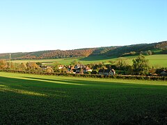
 Stoughton seen from the churchyard | |
Location within West Sussex | |
| Area | 28.97 km2 (11.19 sq mi) [1] |
| Population | 659. 2011 Census[2] |
| • Density | 22/km2 (57/sq mi) |
| OS grid reference | SU802114 |
| • London | 53 miles (85 km) NE |
| Civil parish |
|
| District | |
| Shire county | |
| Region | |
| Country | England |
| Sovereign state | United Kingdom |
| Post town | Chichester |
| Postcode district | PO18 9 |
| Dialling code | 023 |
| Police | Sussex |
| Fire | West Sussex |
| Ambulance | South East Coast |
| UK Parliament | |
Stoughton is a village and civil parish in the District of Chichester in West Sussex, England located nine kilometres (5.6 miles) north west of Chichester east of the B2146 road, on a lane leading to East Marden. The parish has a land area of 2,987 hectares (7,380 acres). In the 2001 census 631 people lived in 255 households, of whom 286 were economically active.[1] At the 2011 Census the population including Walderton had increased to 659.[2] The parish is crossed from west to east by the Monarch's Way long-distance footpath, which passes through the villages of Stoughton and Walderton. There is one pub, The Hare and Hounds.
Famous 19th-century cricketer George Brown was born in the village.
- ^ a b "2001 Census: West Sussex – Population by Parish" (PDF). West Sussex County Council. Archived from the original (PDF) on 8 June 2011. Retrieved 22 May 2009.
- ^ a b "Civil parish population 2011". Neighbourhood Statistics. Office for National Statistics. Retrieved 15 October 2015.
