Stow, Massachusetts | |
|---|---|
 Town center of Stow | |
| Motto(s): "A place for growing up in and a place for coming back to" | |
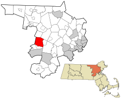
 Location of Stow in Middlesex County, Massachusetts | |
| Coordinates: 42°26′13″N 71°30′22″W / 42.43694°N 71.50611°W | |
| Country | United States |
| State | Massachusetts |
| County | Middlesex |
| Settled | c. 1660 |
| Established | 1669 |
| Incorporated | May 16, 1683 |
| Government | |
| • Type | Open town meeting |
| • Town Administrator | Denise Dembkowski |
| Area | |
• Total | 18.1 sq mi (46.9 km2) |
| • Land | 17.6 sq mi (45.6 km2) |
| • Water | 0.5 sq mi (1.2 km2) |
| Elevation | 231 ft (70 m) |
| Population (2020) | |
• Total | 7,174 |
| • Density | 407.6/sq mi (157.4/km2) |
| Time zone | UTC−5 (Eastern) |
| • Summer (DST) | UTC−4 (Eastern) |
| ZIP Code | 01775 |
| Area code | 351 / 978 |
| FIPS code | 25-68050 |
| GNIS feature ID | 0618236 |
| Website | www.stow-ma.gov |
Stow is a town in Middlesex County, Massachusetts, United States. The town is located 21 miles (34 km) west of Boston, in the MetroWest region of Massachusetts. The population was 7,174 at the 2020 census.[1] Stow was officially incorporated in 1683 with an area of approximately 40 square miles (100 km2).
Over centuries it gave up land as newer, smaller towns were created, ceding land to Harvard (1732), Shirley (1765), Boxborough (1783), Hudson (1866) and Maynard (1871). Stow now has an area of 18.1 square miles (47 km2). With the exception of factories at Assabet Village and Rock Bottom (later Maynard and Gleasondale), Stow was primarily sparsely settled farm and orchard land until the 1950s.
- ^ "Census - Geography Profile: Stow town, Middlesex County, Massachusetts". United States Census Bureau. Retrieved November 6, 2021.
