Strafford County | |
|---|---|
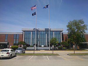
 Strafford County Courthouse | |
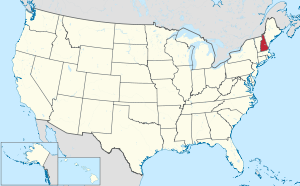
 Location within the U.S. state of New Hampshire | |
 New Hampshire's location within the U.S. | |
| Coordinates: 43°15′30″N 70°58′34″W / 43.258289°N 70.976105°W | |
| Country | |
| State | |
| Founded | 1771 |
| Named for | William Wentworth, 2nd Earl of Strafford |
| Seat | Dover |
| Largest city | Dover |
| Area | |
• Total | 382.6 sq mi (991 km2) |
| • Land | 367.6 sq mi (952 km2) |
| • Water | 15.0 sq mi (39 km2) 3.9% |
| Population (2020) | |
• Total | 130,889 |
• Estimate (2022) | 132,275 |
| • Density | 356.1/sq mi (137.5/km2) |
| Time zone | UTC−5 (Eastern) |
| • Summer (DST) | UTC−4 (EDT) |
| Congressional district | 1st |
| Website | co |
Strafford County is a county in the U.S. state of New Hampshire. As of the 2020 census, the population was 130,889.[1] Its county seat is Dover.[2] Strafford County was one of the five original counties identified for New Hampshire in 1769. It was named after William Wentworth, 2nd Earl of Strafford in the mistaken belief that he was the ancestor of governor John Wentworth – although they were distantly related, William had no descendants. The county was organized at Dover in 1771. In 1840, the size of the original county was reduced with the creation of Belknap County.
Strafford County constitutes a portion of the Boston-Cambridge-Newton, MA-NH Metropolitan Statistical Area as well as of the greater Boston-Worcester-Providence, MA-RI-NH-CT Combined Statistical Area. It is estimated to be New Hampshire's county with the highest percentage growth over the 2010–2019 period.[3]
- ^ "State & County QuickFacts". United States Census Bureau. Retrieved January 14, 2024.
- ^ "Find a County". National Association of Counties. Retrieved June 7, 2011.
- ^ "U.S. Census Bureau QuickFacts: Strafford County, New Hampshire". www.census.gov. Retrieved April 11, 2021.
