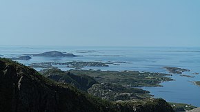
Strandflat (Norwegian: strandflate[1]) is a landform typical of the Norwegian coast consisting of a flattish erosion surface on the coast and near-coast seabed. In Norway, strandflats provide room for settlements and agriculture, constituting important cultural landscapes.[1] The shallow and protected waters of strandflats are valued fishing grounds that provide sustenance to traditional fishing settlements.[1] Outside Norway proper, strandflats can be found in other high-latitude areas, such as Antarctica, Alaska, the Canadian Arctic, the Russian Far North, Greenland, Svalbard, Sweden, and Scotland.
The strandflats are usually bounded on the landward side by a sharp break in slope, leading to mountainous terrain or high plateaux. On the seaward side, strandflats end at submarine slopes.[2][3] The bedrock surface of strandflats is uneven and tilts gently towards the sea.[3]
The concept of a strandflat was introduced in 1894 by Norwegian geologist Hans Reusch.[4][5]
- ^ a b c Bryhni, Inge (2018-05-16). "strandflate". In Helle, Knut (ed.). Store norske leksikon (in Norwegian). Oslo: Kunnskapsforlaget.
- ^ Cite error: The named reference
klemsdalencyclowas invoked but never defined (see the help page). - ^ a b Corner, Geoffrey (2004). "Scandes Mountains". In Seppälä, Matti (ed.). The Physical Geography of Fennoscandia. Oxford University Press. pp. 240–254. ISBN 978-0-19-924590-1.
- ^ Lidmar-Bergström, K.; Olsson, S.; Roaldset, E. (1999). "Relief features and palaeoweathering remnants in formerly glaciated Scandinavian basement areas". In Thiry, Médard; Simon-Coinçon, Régine (eds.). Palaeoweathering, Palaeosurfaces and Related Continental Deposits. Special publication of the International Association of Sedimentologists. Vol. 27. Blackwell Science Ltd. pp. 275–301. ISBN 0-632-05311-9.
- ^ Cite error: The named reference
Odleivetal2013was invoked but never defined (see the help page).