Strathblane
| |
|---|---|
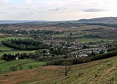
 A view over Strathblane from Ballagan | |
Location within the Stirling council area | |
| Area | 17 sq mi (44 km2) |
| Population | 2,000 (2022)[1] |
| • Density | 54/km2 (140/sq mi) |
| OS grid reference | NS561794 |
| • Edinburgh | 46 mi (74 km) E |
| • London | 358 mi (576 km) SSE |
| Civil parish |
|
| Council area | |
| Lieutenancy area | |
| Country | Scotland |
| Sovereign state | United Kingdom |
| Post town | GLASGOW |
| Postcode district | G63 |
| Dialling code | 01360 |
| Police | Scotland |
| Fire | Scottish |
| Ambulance | Scottish |
| UK Parliament | |
| Scottish Parliament | |
Strathblane (Scottish Gaelic: Strath Bhlàthain,[2] pronounced [s̪t̪ɾahˈvl̪ˠaː.ɪɲ]) is a village and parish in the registration county of Stirling, situated in the southwestern part of the Stirling council area, in central Scotland. It lies at the foothills of the Campsie Fells and the Kilpatrick Hills on the Blane Water, 12 miles (19 km) north of Glasgow, 14 miles (23 km) east-southeast of Dumbarton, and 20 miles (32 km) southwest of Stirling. Strathblane is a dormitory village for Greater Glasgow, and has a total resident population of 1,811.[3]
Historically, Strathblane was the name of a parish in Stirlingshire which comprised three villages: Edenkill, Netherton and Mugdock.[4] Mugdock was the ancient seat of the Earls of Lennox,[5] and to the east of Strathblane lies the town of Lennoxtown. Blanefield is a settlement contiguous with Strathblane's northwestern fringe. To the west is the volcanic plug Dumgoyne, Glengoyne Distillery and the Trossachs National Park. The West Highland Way—a long-distance trail—passes close to the village.
The Gaelic name Strath Bhlàthain translates to English as "the valley of the Blane", with reference to the Blane Water, a watercourse. The Blane Water (Uisge Bhlàthain) has also been referred to as Beul-abhainn (Scottish Gaelic pronunciation: [ˈpial̪ˠa.ɪɲ]) meaning "mouth-river" after the numerous burns merging. One of its tributaries, the Ballagan Burn passes over the waterfall the Spout of Ballagan which shows 192 alternate strata of coloured shales and limestone (including pure alabaster). The Blane flows into the Endrick, which, in its turn, flows westward to Loch Lomond.
- ^ "Mid-2020 Population Estimates for Settlements and Localities in Scotland". National Records of Scotland. 31 March 2022. Retrieved 31 March 2022.
- ^ Newton, Michael (1999). Bho Chluaidh Gu Calasraid: From the Clyde to Callander. Acair Ltd. ISBN 978-0-86152-265-1.
- ^ "Comparative Population Profile: Strathblane Locality Scotland". 2001 Census Online. Archived from the original on 19 May 2011. Retrieved 15 February 2008.
- ^ "Stonehouse - Stromness Pages 500-519 A Topographical Dictionary of Scotland". British History Online. S Lewis, London 1846. Retrieved 7 April 2023.
- ^ Skene, William Forbes (2007). Four Ancient Books of Wales. Forgotten Books. p. 118. ISBN 978-1-60506-165-8.
