| Strathfield South Sydney, New South Wales | |||||||||||||||
|---|---|---|---|---|---|---|---|---|---|---|---|---|---|---|---|
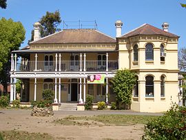
 Brundah, a Victorian style house on the former Leigh College Campus | |||||||||||||||
Location of Strathfield South in Greater Sydney | |||||||||||||||
 | |||||||||||||||
| Coordinates | 33°53′22″S 151°04′59″E / 33.8894°S 151.0831°E | ||||||||||||||
| Population | 3,636 (2021 census)[1] | ||||||||||||||
| Postcode(s) | 2136[2] | ||||||||||||||
| Elevation | 15 m (49 ft) | ||||||||||||||
| Location | 13 km (8 mi) west of Sydney CBD | ||||||||||||||
| LGA(s) | Strathfield Council | ||||||||||||||
| State electorate(s) | Strathfield | ||||||||||||||
| Federal division(s) | Watson | ||||||||||||||
| |||||||||||||||
Strathfield South is a suburb, in the Inner West of Sydney, Australia in the state of New South Wales, 13 kilometres west of the Sydney central business district, in the Strathfield local government area. The area was historically part of Druitt Town. Later it was part of Enfield, until Enfield Council was absorbed into Strathfield and Burwood councils, after which the part within Strathfield council was renamed Strathfield South.
North Strathfield and Strathfield are separate suburbs, to the north. Strathfield South is located between Liverpool Road (Hume Highway) and the Cooks River, bordered on the east by Coronation Parade and to the west by the Enfield Marshalling Yards.
- ^ Australian Bureau of Statistics (28 June 2022). "Strathfield South (State Suburb)". 2021 Census QuickStats. Retrieved 17 October 2024.
- ^ "Strathfield South Postcode, NSW - Australia Post". Australia Post. Retrieved 22 April 2019.
