Strongsville, Ohio | |
|---|---|
 North side of Strongsville's Town Square | |
| Nickname: Crossroads of the Nation | |
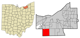
 Location in Cuyahoga County and the state of Ohio. | |
 Location of Ohio in the United States | |
| Coordinates: 41°18′46″N 81°49′55″W / 41.31278°N 81.83194°W | |
| Country | United States |
| State | Ohio |
| County | Cuyahoga |
| Township created | 1818 |
| Village created | 1923 |
| Incorporated | 1961 |
| Government | |
| • Type | Mayor-council |
| • Mayor | Thomas Perciak (R)[1] |
| Area | |
| • Total | 24.63 sq mi (63.79 km2) |
| • Land | 24.62 sq mi (63.77 km2) |
| • Water | 0.01 sq mi (0.02 km2) 0.04% |
| Elevation | 932 ft (284 m) |
| Population (2020) | |
| • Total | 46,491 |
| • Density | 1,888.19/sq mi (729.04/km2) |
| census | |
| Time zone | UTC-5 (EST) |
| • Summer (DST) | UTC-4 (EDT) |
| Zip code | 44136, 44149 |
| Area code | 440 |
| FIPS code | 39-75098 [4] |
| GNIS feature ID | 1065396 [3] |
| Website | www.strongsville.org |
Strongsville is a city in Cuyahoga County, Ohio, United States, and a suburb of Cleveland. As of the 2020 census, its population was 46,491.
The city's nickname, Crossroads of the Nation, originated from the intersection between the Baltimore and Ohio Railroad and Southwestern Electric Line that connected Cleveland and Wooster, Ohio.[5] As the railroad line ceased operation in 1931, the motto and city seal have been adapted to reflect the modern-day intersection of Interstate 71 and the Ohio Turnpike.[6]
- ^ Exner, Rich (November 16, 2013). "Democrats outnumber Republicans as mayors in Cuyahoga County, 39-14". Cleveland.com. Retrieved January 30, 2016.
- ^ "ArcGIS REST Services Directory". United States Census Bureau. Retrieved September 20, 2022.
- ^ a b U.S. Geological Survey Geographic Names Information System: Strongsville, Ohio
- ^ "U.S. Census website". United States Census Bureau. Retrieved January 31, 2008.
- ^ "Strongsville: A Strong community evolves at the 'Crossroads' (PHOTOS)". August 6, 2013. Retrieved September 1, 2016.
- ^ "City of Strongsville Government - About - Facebook". Facebook. Retrieved September 1, 2016.

