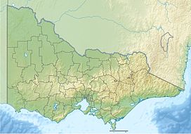
| Strzelecki Ranges | |
|---|---|
| Tolone[1] | |
 View of the Strzelecki Ranges looking towards Mirboo North. | |
| Highest point | |
| Peak | Mount Tassie |
| Elevation | 740 m (2,430 ft) AHD |
| Geography | |
| Country | Australia |
| Region | Victoria |
| Range coordinates | 38°19′42″S 145°55′32″E / 38.32833°S 145.92556°E[2] |
The Strzelecki Ranges (/strɛzˈlɛki/ strehz-LECK-ee) is a set of low mountain ridges located in the West Gippsland and South Gippsland regions of the Australian state of Victoria.
The Ranges are named after Paweł Edmund Strzelecki, a Polish explorer, who with the assistance of Charley Tarra the small party's Aboriginal guide, led an expedition through this region in 1840.[3]
They also form a biogeographic subregion of the South Eastern Highlands.[4] "Land of the Lyrebird"[5] is also a common alternative name for the Strzelecki Ranges based on a popular 1920s book.[6]
- ^ "Strzelecki Ranges: Historical information: 5183". Vicnames. 12 August 1991. Retrieved 7 August 2014.
- ^ "Strzelecki Ranges: 26642". Vicnames. 2 May 1966. Retrieved 7 August 2014.
- ^ The Bush – by Don Watson. Penguin/Hamish Hamilton. 2014. 427 pages. Pages 6 – 7
- ^ "Australia's bioregions (IBRA)". Department of Sustainability, Environment, Water, Population and Communities. Commonwealth of Australia. 2012. Retrieved 13 January 2013.
- ^ "Land of the Lyrebird". 1920.
- ^ "Strzelecki Ranges, Land of the Lyrebird". Commonwealth of Australia. 2014. Retrieved 24 July 2018.
