Stuart Highway –South Australia | |
|---|---|
 | |
| The highway in the far north of South Australia | |
 | |
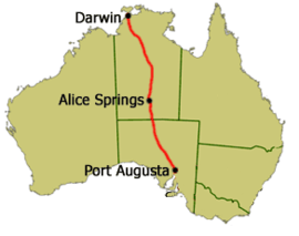
Map of mainland Australia with the Stuart Highway highlighted in red | |
| Coordinates |
|
| General information | |
| Type | Highway |
| Length | 2,720 km (1,690 mi)[1] |
| Route number(s) |
|
| Former route number |
|
| Major junctions | |
| North end | Daly Street Darwin |
| |
| South end | Port Augusta, South Australia |
| Location(s) | |
| Region | Far North[2] |
| Major settlements | Katherine, Daly Waters, Tennant Creek, Alice Springs, Coober Pedy |
| Highway system | |
| ---- | |
Stuart Highway is a major Australian highway. It runs from Darwin, in the Northern Territory, via Tennant Creek and Alice Springs, to Port Augusta in South Australia; it has a distance of 2,720 km (1,690 mi). Its northern and southern extremities are segments of Australia's Highway 1. The principal north–south route through the central interior of mainland Australia, the highway is often referred to simply as "The Track".
The highway is named after Scottish explorer John McDouall Stuart, who was the first European to cross Australia from south to north.[3] The highway approximates the route Stuart took.
- ^ "Stuart Highway" (Map). Google Maps. Retrieved 18 June 2022.
- ^ "Location SA Map viewer with regional layers". Government of South Australia. Archived from the original on 23 March 2023. Retrieved 16 June 2022.
- ^ Exploring the Stuart Highway: further than the eye can see, 1997, p. 6