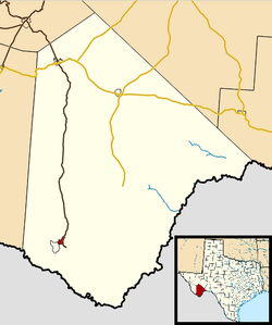
Study Butte, Texas | |
|---|---|
 Location in Brewster County and the state of Texas | |
| Coordinates: 29°20′06″N 103°32′32″W / 29.33500°N 103.54222°W | |
| Country | United States |
| State | Texas |
| County | Brewster |
| Area | |
• Total | 4.7 sq mi (12.3 km2) |
| • Land | 4.7 sq mi (12.3 km2) |
| • Water | 0.0 sq mi (0.0 km2) |
| Elevation | 2,579 ft (786 m) |
| Population (2020) | |
• Total | 200 |
| • Density | 42/sq mi (16/km2) |
| Time zone | UTC-6 (Central (CST)) |
| • Summer (DST) | UTC-5 (CDT) |
| FIPS code | 48-70688[2] |
| GNIS feature ID | 2584741[1] |
Study Butte (/ˈstjuːdi ˌbjuːt/ STEW-dee BEWT[3]) is a census-designated place (CDP) in Brewster County, Texas, United States. The population was 200 at the 2020 census, down from 233 at the 2010 census.[4] At the 2000 census, the area was part of the Study Butte-Terlingua CDP.
- ^ a b U.S. Geological Survey Geographic Names Information System: Study Butte, Texas
- ^ "U.S. Census website". United States Census Bureau. Retrieved January 31, 2008.
- ^ "Towns S Texas Pronunciation Guide". Archived from the original on February 14, 2008.
- ^ "Geographic Identifiers: 2010 Demographic Profile Data (G001): Study Butte CDP, Texas". U.S. Census Bureau, American Factfinder. Archived from the original on February 12, 2020. Retrieved April 22, 2014.