Stung Treng
ស្ទឹងត្រែង (Khmer) | |
|---|---|
| Stung Treng Province ខេត្តស្ទឹងត្រែង (Khmer) | |
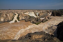
 Sopheakmitt Waterfall | |
 Map of Cambodia highlighting Stung Treng | |
| Coordinates: 13°31′N 105°57′E / 13.517°N 105.950°E | |
| Country | |
| Provincial status | 1907 |
| Capital | Stung Treng |
| Subdivisions | 1 municipality; 5 districts |
| Government | |
| • Governor | Sor Soputra (CPP) |
| • National Assembly | 1 / 125
|
| Area | |
• Total | 11,092 km2 (4,283 sq mi) |
| • Rank | Ranked 8th |
| Population (2023)[1] | |
• Total | |
| • Rank | 21st |
| • Density | 14/km2 (40/sq mi) |
| • Rank | 23rd |
| Demographics | |
| • Language(s) | |
| Time zone | UTC+07:00 (ICT) |
| Dialing code | +855 |
| ISO 3166 code | KH-19 |
| Website | www |
Stung Treng[2] (Khmer: ស្ទឹងត្រែង, UNGEGN: Stœ̆ng Trêng [stɨŋ traeŋ]; Lao: ຊຽງແຕງ, Xiang Taeng, pronounced [sía̯ŋ tɛ̀ːŋ]; lit. "River of Reeds") is a province of Cambodia in the northeast. It borders the provinces of Ratanakiri to the east, Mondulkiri and Kratié to the south and Kampong Thom and Preah Vihear to the west. Its northern boundary is Cambodia's international border with Laos. The Mekong River bisects the province. The province is mostly covered by forest, but logging and fishing put high pressure on the forest and fishery reserves.[3]
- ^ "General Population Census of the Kingdom of Cambodia 2019 – Final Results" (PDF). National Institute of Statistics. Ministry of Planning. 26 January 2021. Retrieved 3 February 2021.
- ^ "Reports by Governments on the Situation in Their Countries And on the Progress Made in the Standardization Of Geographical Names Since the Seventh Conference" (PDF). unstats.un.org. Archived (PDF) from the original on 2014-10-29. Retrieved 2014-10-29.
- ^ "Stung Treng – How does Rural Cambodian Earn a Livelihood? | the Povertist". 4 April 2015.
