| Sturgeon Bay Ship Canal | |
|---|---|
 Aerial view of the canal. Lake Michigan at lower right | |
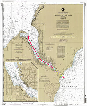
 A 1997 NOAA chart with the canal highlighted in yellow and the dredged channel in red | |
| Location | Door County, Wisconsin |
| Country | United States |
| Coordinates | 44°47′56″N 87°19′14″W / 44.79889°N 87.32056°W |
| Specifications | |
| Length | 1.3 miles (2.1 km) |
| Locks | None |
| Status | Open |
| Navigation authority | U.S. Army Corps of Engineers |
| Geography | |
| Start point | Lake Michigan |
| End point | Sturgeon Bay |
The Sturgeon Bay Ship Canal is a ship canal connecting Sturgeon Bay with Lake Michigan across the Door Peninsula in Door County, Wisconsin.[1][2] A dredged channel continues through Sturgeon Bay to Green Bay. This combined waterway allows ships to sail between Lake Michigan and Green Bay without traversing the dangerous Porte des Morts strait.
The canal is approximately 1.3 miles (2.1 km) long, cutting through the eastern side of the peninsula in a northwest-to-southeast orientation. There are no locks.