This article needs additional citations for verification. (October 2023) |
| Port of Suape | |
|---|---|
 Port of Suape industrial complex | |
 Click on the map for a fullscreen view | |
| Location | |
| Country | Brazil |
| Location | Ipojuca and Cabo de Santo Agostinho, Pernambuco |
| Coordinates | 8°23′56″S 34°57′44″W / 8.39889°S 34.96222°W |
| Details | |
| Opened | 1983 |
| Type of harbour | Seaport |
| Statistics | |
| Annual cargo tonnage | 23.6 million tonnes (2017) |


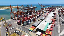
Suape Port is one of the main ports of Brazil and Latin America. It's located in the city of Ipojuca and Cabo de Santo Agostinho, in the state of Pernambuco. It's the largest public port in the Northeast Region and occupies the fifth position in the national ranking.[1]
The port is located inside the Recife Metropolitan Area, 40 km south of the city. Suape is a non-tidal port that services ships 365 days a year. It plays an important role in the economy of the state of Pernambuco. In the 21st century Suape became Pernambuco's main focus for development.[2]