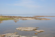
The sub-Cambrian peneplain is an ancient, extremely flat, erosion surface (peneplain) that has been exhumed and exposed by erosion from under Cambrian strata over large swathes of Fennoscandia. Eastward, where this peneplain dips below Cambrian and other Lower Paleozoic cover rocks. The exposed parts of this peneplain are extraordinarily flat with relief of less than 20 m. The overlying cover rocks demonstrate that the peneplain was flooded by shallow seas during the Early Paleozoic.[1] Being the oldest identifiable peneplain in its area the Sub-Cambrian peneplain qualifies as a primary peneplain.[2][3]
The surface was first identified by Arvid Högbom in a 1910 publication, with Sten Rudberg publishing the first extensive map in 1954. This mapping has been improved upon by Karna Lidmar-Bergström since the 1980s.[4][5]
- ^ Lidmar-Bergström, Karna; Bonow, Johan M.; Japsen, Peter (2013). "Stratigraphic Landscape Analysis and geomorphological paradigms: Scandinavia as an example of Phanerozoic uplift and subsidence". Global and Planetary Change. 100: 153–171. doi:10.1016/j.gloplacha.2012.10.015.
- ^ Lidmar-Bergström (1988). "Denudation surfaces of a shield area in southern Sweden". Geografiska Annaler. 70 A (4): 337–350. doi:10.1080/04353676.1988.11880265.
- ^ Fairbridge, Rhodes W.; Finkl Jr., Charles W. (1980). "Cratonic erosion unconformities and peneplains". The Journal of Geology. 88 (1): 69–86. doi:10.1086/628474.
- ^ Lidmar-Bergströrm, Karna (1996). "Long term morphotectonic evolution in Sweden". Geomorphology. 16: 33–59. doi:10.1016/0169-555X(95)00083-H.
- ^ Cite error: The named reference
Karna2017was invoked but never defined (see the help page).