Suba
صوبا Soba, Sobetha, Zova | |
|---|---|
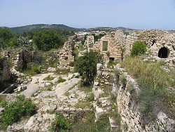
 Remains of the Suba village square and surrounding buildings, formerly the Belmont Castle courtyard | |
| Etymology: The heap[1] | |
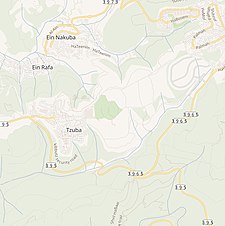
A series of historical maps of the area around Suba, Jerusalem (click the buttons) | |
Location within Mandatory Palestine | |
| Coordinates: 31°47′5″N 35°7′34″E / 31.78472°N 35.12611°E | |
| Palestine grid | 162/132 |
| Geopolitical entity | Mandatory Palestine |
| Subdistrict | Jerusalem |
| Date of depopulation | 13 July 1948[4] |
| Area | |
| • Total | 4,102 dunams (4.102 km2 or 1.584 sq mi) |
| Population (1945) | |
| • Total | 620[2][3] |
| Cause(s) of depopulation | Military assault by Yishuv forces |
| Current Localities | Tzova[5] |

Suba (Arabic: صوبا, romanized: Ṣūbā) was a Palestinian Arab village west of Jerusalem that was depopulated and destroyed in 1948. The site of the village lies on the summit of a conical hill called Tel Tzova (Hebrew: תל צובה), or Jabal Suba, rising 769 meters above sea level, and it was built on the ruins of a Crusader castle.
- ^ Palmer, 1881, p. 329
- ^ Government of Palestine, Department of Statistics, 1945, p. 25
- ^ a b Government of Palestine, Department of Statistics. Village Statistics, April, 1945. Quoted in Hadawi, 1970, p. 58
- ^ Morris, 2004, p. xx, village #353. Also gives cause of depopulation.
- ^ Morris, 2004, p. xxi, settlement #32.


