| Sudd | |
|---|---|
 Sudd Swamp from space, May 1993. This photograph was taken during the driest time of the year | |
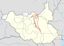
 Location of the Sudd in South Sudan | |
| Ecology | |
| Realm | Afrotropical |
| Biome | flooded grasslands and savannas |
| Borders | |
| Geography | |
| Area | 57,000 km2 (22,000 sq mi) |
| Country | South Sudan |
| Coordinates | 8°N 31°E / 8°N 31°E |

| |
| Designated | 5 June 2006 |
| Reference no. | 1622[1] |

The Sudd (Arabic: السد, romanized: as-Sudd, Dinka: Toc) is a vast swamp in South Sudan, formed by the White Nile's Baḥr al-Jabal section. The Arabic word sudd is derived from sadd (سد), meaning "barrier"[2] or "obstruction".[3] The term "the sudd" has come to refer to any large solid floating vegetation island or mat. The area which the swamp covers is one of the world's largest wetlands and the largest freshwater wetland in the Nile Basin.
For many years the swamp, and especially its thicket of vegetation, proved an impenetrable barrier to navigation along the Nile. The ancient Egyptians failed to penetrate the Sudd and reach the areas south of it.[4] In AD 61, a party of Roman soldiers sent by the Emperor Nero proceeded up the White Nile but were not able to get beyond the Sudd, which marked the limit of Roman penetration into equatorial Africa.[5] For the same reasons in later times, the search for the source of the Nile was particularly difficult; it eventually involved overland expeditions from the central African coast, so as to avoid having to travel through the Sudd.
In 2019, a study suggested that increased water flows into the Sudd may be partly causing up to a third of the whole West African rise in atmospheric methane levels over the previous decade.[6][7]
- ^ "Sudd". Ramsar Sites Information Service. Retrieved 25 April 2018.
- ^ Gaudet, John. J.; Falconer, A. (1983). Remote sensing for tropical freshwater bodies. The problem of floating islands on Lake Naivasha. Nairobi, Kenya: Regional Remote Sensing Facility.
- ^ The New Oxford American Dictionary (NOAD), 3rd edition.
- ^ Dumont, Henri J., ed. (2009). "A Description of the Nile Basin, and a Synopsis of Its History, Ecology, Biogeography, Hydrology, and Natural Resources". The Nile Origin, Environments, Limnology and Human Use. Monographiae Biologicae. Vol. 89. Springer Science + Business Media B.V. pp. 1–21. ISBN 978-1-4020-9725-6.
- ^ Kirwan, L. P. (1957). "Rome beyond The Southern Egyptian Frontier". Geographical Journal. 123 (1): 13–19. doi:10.2307/1790717. JSTOR 1790717 – via JSTOR.
- ^ Lunt, Mark F.; Palmer, Paul I.; Feng, Liang; et al. (2019). "An increase in methane emissions from tropical Africa between 2010 and 2016 inferred from satellite data". Atmos. Chem. Phys. 19 (23): 14721–14740. Bibcode:2019ACP....1914721L. doi:10.5194/acp-19-14721-2019. hdl:20.500.11820/013be268-2ebf-478a-a9d0-1e80f8c4b888. S2CID 198448426.
- ^ "Climate change: Methane pulse detected from South Sudan wetlands". BBC News. 2019.