Suffolk | |
|---|---|
 | |
| Coordinates: 52°12′N 1°00′E / 52.200°N 1.000°E | |
| Sovereign state | United Kingdom |
| Constituent country | England |
| Region | East |
| Established | Ancient |
| Time zone | UTC+0 (GMT) |
| • Summer (DST) | UTC+1 (BST) |
| UK Parliament | List of MPs |
| Police | Suffolk Constabulary |
| Ceremonial county | |
| Lord Lieutenant | Clare FitzRoy, Countess of Euston |
| High Sheriff | Bridget McIntyre[1] (2020–21) |
| Area | 3,800 km2 (1,500 sq mi) |
| • Rank | 8th of 48 |
| Population (2022)[2] | 768,555 |
| • Rank | 33rd of 48 |
| Density | 202/km2 (520/sq mi) |
| Ethnicity | 97.2% White |
| Non-metropolitan county | |
| County council | Suffolk County Council |
| Control | Conservative |
| Admin HQ | Ipswich |
| Area | 3,800 km2 (1,500 sq mi) |
| • Rank | 4th of 21 |
| Population (2022)[3] | 768,555 |
| • Rank | 14th of 21 |
| Density | 202/km2 (520/sq mi) |
| ISO 3166-2 | GB-SFK |
| GSS code | E10000029 |
| ITL | UKH14 |
| Website | suffolk |
| Districts | |
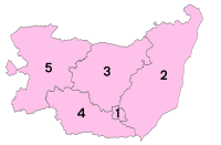
 Districts of Suffolk | |
| Districts | |
Suffolk (/ˈsʌfək/ SUF-ək) is a ceremonial county in the East of England and East Anglia. It is bordered by Norfolk to the north, the North Sea to the east, Essex to the south, and Cambridgeshire to the west. Ipswich is the largest settlement and the county town.
The county has an area of 3,798 km2 (1,466 sq mi) and a population of 758,556. After Ipswich (144,957) in the south, the largest towns are Lowestoft (73,800) in the north-east and Bury St Edmunds (40,664) in the west. Suffolk contains five local government districts, which are part of a two-tier non-metropolitan county also called Suffolk.
The Suffolk coastline is a complex habitat, formed by London clay and crag underlain by chalk and therefore susceptible to erosion. It contains several deep estuaries, including those of the rivers Blyth, Deben, Orwell, Stour, and Alde/Ore; the latter is 25.5 km (15.8 mi) long and separated from the North Sea by Orford Ness, a large spit. Large parts of the coast are backed by heath and wetland habitats, such as Sandlings.[4] The north-east of the county contains part of the Broads, a network of rivers and lakes. Inland, the landscape is flat and gently undulating, and contains part of Thetford Forest on the Norfolk border and Dedham Vale on the Essex border.
It is also known for its extensive farming and has largely arable land. Newmarket is known for horse racing, and Felixstowe is one of the largest container ports in Europe.[5]
- ^ "No. 62943". The London Gazette. 13 March 2020. p. 5161.
- ^ "Mid-2022 population estimates by Lieutenancy areas (as at 1997) for England and Wales". Office for National Statistics. 24 June 2024. Retrieved 26 June 2024.
- ^ "Mid-Year Population Estimates, UK, June 2022". Office for National Statistics. 26 March 2024. Retrieved 3 May 2024.
- ^ "Features and Habitats". coastandheaths.org. Archived from the original on 2 September 2023. Retrieved 5 July 2023.
- ^ "Top 50 Container Ports in Europe". World Shipping Council. Archived from the original on 27 August 2013. Retrieved 17 July 2015.


