Suffolk County | |
|---|---|
 Suffolk County Courthouse | |
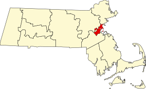
 Location within the U.S. state of Massachusetts | |
 Massachusetts's location within the U.S. | |
| Coordinates: 42°20′06″N 71°04′25″W / 42.334949°N 71.073494°W | |
| Country | |
| State | |
| Founded | May 10, 1643 |
| Named for | Suffolk |
| Seat | Boston |
| Largest city | Boston |
| Area | |
| • Total | 120 sq mi (300 km2) |
| • Land | 58.15 sq mi (150.6 km2) |
| • Water | 62 sq mi (160 km2) 52% |
| Population (2020) | |
| • Total | 797,936 |
| • Density | 13,698/sq mi (5,289/km2) |
| Time zone | UTC−5 (Eastern) |
| • Summer (DST) | UTC−4 (EDT) |
| Congressional districts | 5th, 7th, 8th |
Suffolk County (/ˈsʌfək/ SUF-ək) is located in the Commonwealth of Massachusetts, in the United States. As of the 2020 census, the population was 797,936,[1] making it the fourth-most populous county in Massachusetts.[2] The county comprises the cities of Boston, Chelsea, and Revere, and the town of Winthrop.[3] The traditional county seat is Boston, the state capital and the largest city in Massachusetts.[4] The county government was abolished in 1999, resulting in Suffolk County now functioning only as an administrative subdivision of state government and a set of communities grouped together for some statistical purposes. Suffolk County is located at the core of the Boston-Cambridge-Newton, MA-NH Metropolitan Statistical Area as well as the greater Boston-Worcester-Providence, MA-RI-NH-CT Combined Statistical Area.
- ^ "Census - Geography Profile: Suffolk County, Massachusetts". Census Bureau QuickFacts. Retrieved May 9, 2018.
- ^ "USA/Massachusetts/Counties". The 192nd General Court of the Commonwealth of Massachusetts. Archived from the original on July 28, 2022. Retrieved July 28, 2022.
- ^ "A Listing of Counties and the Cities and Towns Within". Secretary of the Commonwealth of Massachusetts.
- ^ "Find a County". National Association of Counties. Archived from the original on May 31, 2011. Retrieved June 7, 2011.
