Sugar Island Township, Michigan | |
|---|---|
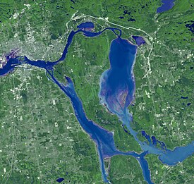
 Satellite view of Sugar Island | |
 Location within Chippewa County | |
| Coordinates: 46°27′55″N 84°12′17″W / 46.46528°N 84.20472°W | |
| Country | United States |
| State | Michigan |
| County | Chippewa |
| Established | 1857 |
| Government | |
| • Supervisor | Mark Eitrem |
| • Clerk | Brittany Behm |
| Area | |
• Total | 76.46 sq mi (198.03 km2) |
| • Land | 49.35 sq mi (127.82 km2) |
| • Water | 27.11 sq mi (70.21 km2) |
| Elevation | 591 ft (180 m) |
| Population (2020) | |
• Total | 653 |
| • Density | 13.2/sq mi (5.1/km2) |
| Time zone | UTC-5 (EST) |
| • Summer (DST) | UTC-4 (EDT) |
| ZIP code(s) | 49783 (Sault Ste. Marie) |
| Area code | 906 |
| FIPS code | 26-77020[2] |
| GNIS feature ID | 1627131[3] |
| Website | Official website |
Sugar Island Township is a civil township of Chippewa County in the U.S. state of Michigan. The population was 653 at the 2020 census. The township consists of Sugar Island, several smaller islands, and the surrounding waters in the St. Marys River.
Some of its land is within the reservation of the Bay Mills Indian Community, a federally recognized tribe and band of Chippewa who have long been in the region of Sault Ste. Marie, Michigan. Native Americans make up one-third of the population on the island.
- ^ Michigan Townships Association (2023). "Sugar Island Township, Chippewa County, Michigan". Retrieved October 13, 2023.
- ^ "U.S. Census website". United States Census Bureau. Retrieved January 31, 2008.
- ^ U.S. Geological Survey Geographic Names Information System: Sugar Island Township, Michigan

