| Sugarloaf Hill | |
|---|---|
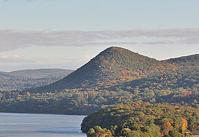
 Looking north towards Sugarloaf Hill from the Bear Mountain Bridge | |
| Highest point | |
| Elevation | 785[1] ft (239 m) |
| Coordinates | 41°21′39″N 73°56′47″W / 41.36083°N 73.94639°W |
| Geography | |
 | |
| Location | Philipstown, New York, U.S. |
| Parent range | Hudson Highlands |
| Topo map | USGS Peekskill |
| Climbing | |
| Easiest route | hiking trail |
Sugarloaf Hill is a 785 ft (239 m) peak along the Hudson River in Putnam County, New York, part of the Hudson Highlands. It was named by the Dutch for its resemblance in outline to a sugarloaf when sailing up the river towards it.[2]
- ^ Dictionary of Altitudes in the United States, Fourth Edition, Henry Gannett, Washington Government Printing Office (1908), p. 742
- ^ Lossing, Benson J. "Chapter XIV". From the Wilderness to the Sea. New York: Virtue & Yorston. Retrieved 2007-04-21.