Sulz am Neckar | |
|---|---|
 Free Baptist Church in Sulz am Neckar | |
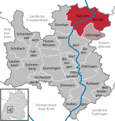
Location of Sulz am Neckar within Rottweil district  | |
| Coordinates: 48°21′46″N 8°37′54″E / 48.36278°N 8.63167°E | |
| Country | Germany |
| State | Baden-Württemberg |
| Admin. region | Freiburg |
| District | Rottweil |
| Subdivisions | 9 Ortsteile |
| Government | |
| • Mayor (2022–30) | Jens Keuchner[1] |
| Area | |
| • Total | 87.60 km2 (33.82 sq mi) |
| Elevation | 443 m (1,453 ft) |
| Population (2022-12-31)[2] | |
| • Total | 12,724 |
| • Density | 150/km2 (380/sq mi) |
| Time zone | UTC+01:00 (CET) |
| • Summer (DST) | UTC+02:00 (CEST) |
| Postal codes | 72168–72172 |
| Dialling codes | 07454 |
| Vehicle registration | RW |
| Website | www.sulz.de |
Sulz am Neckar is a town in the district of Rottweil, in Baden-Württemberg, Germany. It is situated on the river Neckar, 22 km north of Rottweil, and 19 km southeast of Freudenstadt.
Sulz am Neckar came in the possession of the Hohengeroldseck in AD 1242.
At Sulz a powerline for traction current crosses the Neckar Valley in a large span, which is mounted on two 61-metre-tall electricity pylons.
- ^ Bürgermeisterwahl Sulz am Neckar 2022, Staatsanzeiger.
- ^ "Bevölkerung nach Nationalität und Geschlecht am 31. Dezember 2022" [Population by nationality and sex as of December 31, 2022] (CSV) (in German). Statistisches Landesamt Baden-Württemberg. June 2023.


