| Sumapaz River | |
|---|---|
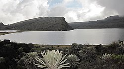
 Lake Chisacá, source of the river | |
| Native name | Río Sumapaz (Spanish) |
| Location | |
| Country | Colombia |
| Physical characteristics | |
| Source | |
| • location | Lake Chisacá, Sumapaz Páramo |
| • coordinates | 4°16′51″N 74°12′25.4″W / 4.28083°N 74.207056°W |
| • elevation | 4,710 m (15,450 ft)[1] |
| Mouth | |
• location | Ricaurte |
• coordinates | 4°15′51″N 74°46′50″W / 4.264257°N 74.780632°W |
• elevation | 289 m (948 ft) |
| Length | 95 km (59 mi) |
| Basin size | 480 km2 (190 sq mi) |
| Basin features | |
| River system | Magdalena River Caribbean Sea |
| Tributaries | |
| • left | Pilar River, San Juan River, Cuja River, Panches River |
The Sumapaz River (Spanish: Río Sumapaz) is a major tributary of the Magdalena River in Colombia. The 95 kilometres (59 mi) long river originates in the Eastern Ranges of the Colombian Andes at the largest páramo in the world; Sumapaz, of which it takes its name. It forms the natural boundary between the departments of Cundinamarca and Tolima.
- ^ (in Spanish) Corporación Autonoma Regional Del Tolima, CORTOLIMA Archived 2007-07-29 at the Wayback Machine
