Sumay | |
|---|---|
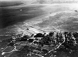
 Sumay in the 1930s | |
 Map of Sumay on Apra Harbor, 1912 | |
Sumay on the Orote Peninsula, Guam | |
| Coordinates: 13°26′13.8″N 144°39′11.5″E / 13.437167°N 144.653194°E | |
| Country | United States |
| Territory | Guam |
| Taking by U.S. government | 1948 |
| Population (1941) | |
| • Total | 1,997 |
Sumay, also Sumai, was a village on the United States territory of Guam. It was located on the north coast of the Orote Peninsula along Apra Harbor. It was inhabited by Chamorro people before contact with Europeans. Sumay became a prosperous port town serving whalers and other sailors in the 1800s and the second most populous settlement on Guam after Hagåtña, the capital of the Spanish Mariana Islands. Following the Capture of Guam by the United States in 1898, the village was the site of Marine Barracks Guam. In the early 1900s, it was a link for two firsts connecting the United States and Asia: the first submarine communications cable for telegraph and the China Clipper, the first air service. After the Japanese invasion of Guam in 1941, the residents were evicted and the village turned into a Japanese military garrison. Sumay was leveled during the U.S. liberation of the island in 1944. The U.S. military prohibited the residents from returning, relocating them to the hills of nearby Sånta Rita-Sumai. In 1948, the U.S. military exercised eminent domain and took all private and commercial property at Sumay. Its former location is now on Naval Base Guam.

